
Coordinates Finder
Find your current latitude and longitude with one tap, or paste any coordinates in decimal, DMS or DDM format and see them converted to every common format — decimal degrees, degrees-minutes-seconds, degrees and decimal minutes, UTM and Open Location Code (Plus Code). Add a second point to get the distance and compass bearing between them.
- Free to use
- No sign-up
- Runs in your browser
Coordinates finder and converter
Navigation & Coordinates Pack
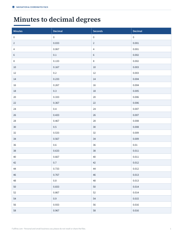
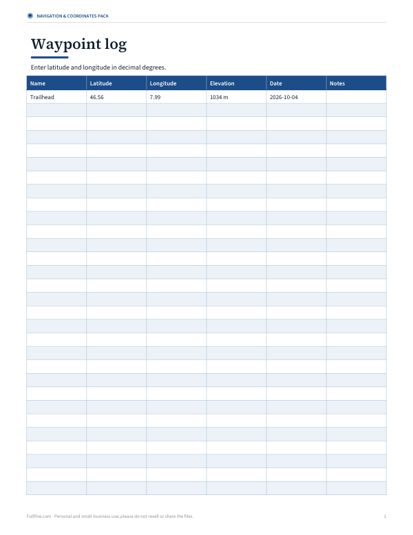
Printable coordinate format cheat sheet, a DMS–decimal conversion table, a waypoint log for hikes and geocaching (Excel), and a UTM grid reference guide.
- Cheat sheet (PDF)
- Conversion table (PDF/XLSX)
- Waypoint log (XLSX)
- UTM guide (PDF)
Formats: PDF, DOCX, XLSX. Instant download after payment (link valid 72 hours, up to 5 downloads). AI-assisted: the templates were drafted with AI help and reviewed and laid out before publishing.
$3.00 USD, one-time 4 files · about $0.75 each
- Instant download
- 7-day refund
- Secure checkout by Stripe
7-day money-back guarantee. Full refund within 7 days of purchase, even after you download.
Free sample: Coordinate Formats Cheat Sheet (PDF, 59 KB)
Full refund within 7 days — see the refund policy and license.
Free printables
Single sheets you can print right now, no sign-up. The full pack adds every sheet in one download plus the editable files.
 Printable UTM Guide PDF
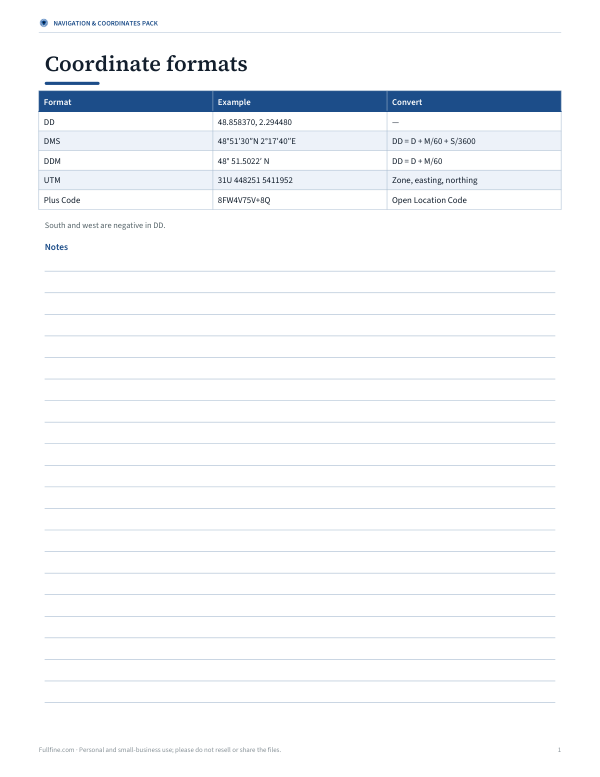
Coordinate formats explained
| Format | Example | Common in |
|---|---|---|
| Decimal degrees (DD) | 48.858370, 2.294480 | Web maps, apps, spreadsheets |
| Degrees, minutes, seconds (DMS) | 48°51′30.13″N 2°17′40.13″E | Paper maps, surveying, aviation charts |
| Degrees and decimal minutes (DDM) | 48° 51.5022′ N, 2° 17.6688′ E | Marine GPS, geocaching |
| UTM | 31U 448251 E 5411952 N | Hiking maps, search and rescue, military grids |
| Plus Code | 8FW4V75V+8Q | Addresses where there are no street numbers |
Latitude comes first and measures north–south (−90° to +90°); longitude comes second and measures east–west (−180° to +180°). In decimal degrees, south and west are negative.
How to convert between formats
- From DMS to decimal: degrees + minutes ÷ 60 + seconds ÷ 3,600, then make it negative for S or W.
- From decimal to DMS: the whole number is degrees; multiply the remainder by 60 for minutes; multiply the new remainder by 60 for seconds.
- From DDM to decimal: degrees + decimal minutes ÷ 60.
Example: 48°51′30″N = 48 + 51/60 + 30/3600 = 48.858333°.
How precise are coordinates?
| Decimal places | Precision (approx.) | Good for |
|---|---|---|
| 2 | 1.1 km | City |
| 3 | 110 m | Neighbourhood |
| 4 | 11 m | Street, large building |
| 5 | 1.1 m | Tree, doorway |
| 6 | 0.11 m | Survey-grade detail |
Phone GPS is usually accurate to about 5–10 metres outdoors, less in cities or indoors. The tool shows the accuracy your device reports.
Distance and bearing
The distance between two points is calculated along the Earth’s surface using the haversine formula on a sphere with the mean Earth radius, which is accurate to within about 0.5% — plenty for planning. The initial bearing is the compass direction you would start travelling from point A to reach point B on the shortest path; on long routes the bearing changes along the way.
Worked example
Entering the Eiffel Tower’s coordinates (48.85837, 2.29448) shows 48°51′30.13″N 2°17′40.13″E, UTM 31U 448251 E 5411952 N and Plus Code 8FW4V75V+8Q. Adding Big Ben in DMS (51°30′03″N 0°07′28″W) gives a great-circle distance of about 340 km (211 miles) with an initial bearing of about 330° — north-north-west.
Latitude and longitude basics
| Term | Meaning |
|---|---|
| Latitude | Angle north or south of the equator (0° at the equator, 90° at the poles) |
| Longitude | Angle east or west of the Prime Meridian through Greenwich (0° to 180°) |
| 1° of latitude | About 111 km (69 miles) everywhere |
| 1° of longitude | About 111 km at the equator, shrinking to 0 at the poles |
| 1 minute of latitude | About 1.85 km — one nautical mile |
Using coordinates in spreadsheets and apps
Spreadsheets and mapping apps work best with decimal degrees in two separate columns — latitude and longitude. To convert a column of DMS values in a spreadsheet, split degrees, minutes and seconds into separate columns and use =D + M/60 + S/3600, adding a minus sign for south or west. When sharing with others, say which format and datum you are using.
Troubleshooting input
- Separate latitude and longitude with a comma or space.
- Use N/S/E/W letters or negative numbers, not both.
- Degree, minute and second symbols are optional: 48 51 30 N 2 17 40 E works.
- If latitude is over 90, the numbers are probably reversed.
Datums and why coordinates can differ
Coordinates are defined relative to a model of the Earth called a datum. GPS and most web maps use WGS 84, but older paper maps and some national systems use different datums, which can shift positions by tens or even hundreds of metres. If coordinates from a paper map don’t match your GPS, check which datum the map uses. The converter assumes WGS 84 throughout.
Coordinates for emergencies and outdoors
| Situation | Best format |
|---|---|
| Calling emergency services | Decimal degrees read slowly, or a Plus Code |
| Hiking with a paper map | UTM or the map’s grid reference |
| Sailing | Degrees and decimal minutes |
| Geocaching | Degrees and decimal minutes |
| Sharing a meeting point | Decimal degrees or a map link |
Before a remote trip, note the coordinates of trailheads and shelters and carry a way to read your position offline.
Sharing coordinates safely
- Share decimal degrees with 5 decimal places for meeting points.
- Double-check the order: latitude, then longitude.
- For emergencies, many services accept coordinates or Plus Codes — read them out slowly.
- Be careful posting your home coordinates publicly.
- Geotagged photos may contain coordinates in their metadata.
Privacy
Your location is only requested when you press “Use my location”, is processed in your browser and is never sent or stored by this page. The optional map link opens OpenStreetMap in a new tab only if you click it.
Frequently asked questions
How do I find my GPS coordinates?
Press “Use my location” and allow access; your coordinates appear in several formats.
Which comes first, latitude or longitude?
Latitude (north–south), then longitude (east–west).
How do I convert DMS to decimal?
Degrees + minutes/60 + seconds/3600, negative for S or W.
What is UTM?
A grid system dividing the Earth into 60 zones with coordinates in metres.
What is a Plus Code?
An Open Location Code that encodes a location as a short alphanumeric code.
How accurate is phone GPS?
Typically 5–10 metres outdoors; less accurate indoors or between tall buildings.
Can I convert UTM back to latitude and longitude?
This tool converts from latitude/longitude; use a GIS app for UTM to latitude/longitude.
What does a negative longitude mean?
West of the Prime Meridian, such as the Americas.
Is my location stored?
No, it stays in your browser.